6th Grade China and Rome Inquiry
Did the Chinese and Romans Know Each Other?
Download the Entire Inquiry Here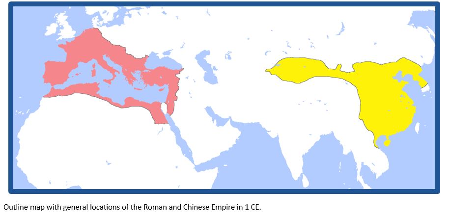
Did the Chinese and Romans Know Each Other?
Download the Entire Inquiry Here
Supporting Question 1- Where were the Roman and Chinese Empires located?
- Source A: Author unknown, map with general locations of the Roman and Chinese Empire in 1 CE, “Locator Map for the Roman Empire and the Chinese Han dynasty,” 2009 NOTE: On the map below, the Roman Empire is highlighted in red and the Chinese empire is highlighted in yellow.
© Gabagool. Reproduced under the Creative Commons Attribution-Share Alike 3.0 Unported License. http://commons.wikimedia.org/wiki/File:RomanandHanEmpiresAD1.png. - Source B: Thomas Lessman, detailed map of Roman and Chinese Empire in 200 CE, “Eastern Hemisphere in 200 AD,” 2008
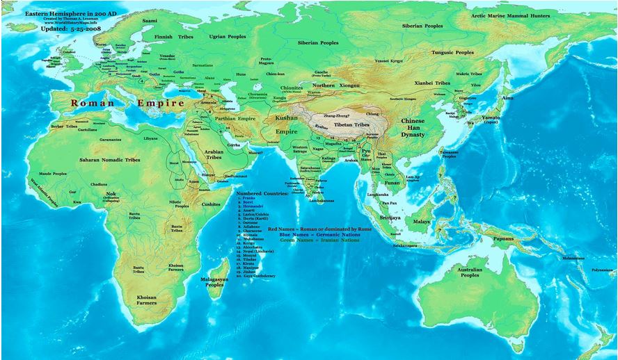
© Thomas Lessman. Reproduced under the Creative Commons Attribution-Share Alike 3.0 Unported License. http://commons.wikimedia.org/wiki/File:East-Hem_200ad.jpg.
Supporting Question 2- What did the Chinese know about the West?
- Source A: Sima Qian, description of Zhang Qian’s travels in the West, Records of the Great Historian and Travels of Zhang Qian (excerpts), 130 BCE Schools Wikipedia sponsored by SOS Children.
- Source B: Map bank: Maps of Chinese exploration
- Map 1: Author unknown, map of Map of Yuezhi migrations in the 1st and 2nd century BCE, 2006.
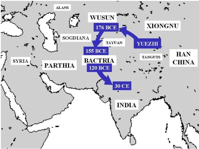 Reproduced under the Creative Commons Attribution-Share Alike 3.0 Unported License. http://commons.wikimedia.org/wiki/File:Yueh-ChihMigrations.jpg
- Map 2: Author unknown, map of Zhan Qian’s travels in the West in the 2nd century BCE, 2005.
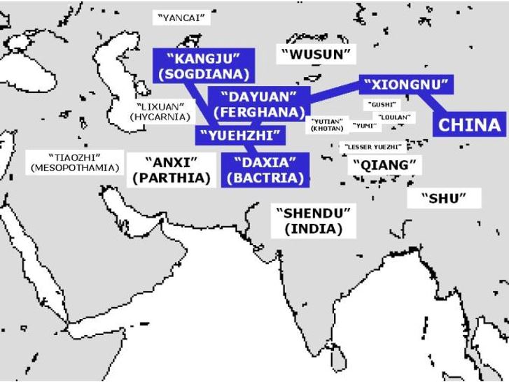 Reproduced under the Creative Commons Attribution-Share Alike 3.0 Unported License. http://commons.wikimedia.org/wiki/File:ZhangQianTravel.jpg
- Source C: Fan Ye, description of the West based on travels of Gan Ying in 97 CE, Hou Hanshu or History of the Han (excerpts), 5th century CE From Through the Jade Gate – China to Rome, Volume I. 2nd Edition. © John Hill. Charleston: CreateSpace, 2015. Used with permission
- Source D: Yu Huan, description of Romans, Weilue or Brief History of the Wei (excerpts), 265 CE From China Meets the West: The “Peoples of the West” During the 3rd Century CE According to the Weilue (forthcoming). © John Hill. 2015
Supporting Question 3- What did the Romans know about the East?
- Source A: Pliny the Elder, description of China, Natural History (excerpts), 77 CE
NOTE: This text appeared in the Roman writer Pliny the Elder’s Natural History VI, 54. Natural History was a far-reaching effort by Pliny the Elder to describe the world. He wrote several volumes on geography, which included the following text about silk production in China. Pliny the Elder refers to the people who created silk as Seres.
The Seres are famous for the woolen substance obtained from their forests; after a soaking in water they comb off the white down of the leaves….So manifold is the labour employed, and so distant is the region of the globe drawn upon, to enable the Roman maiden to flaunt transparent clothing in public.
Public domain.
- Source B: Claudius Ptolemy, a description and map of the Asia, Geography (excerpt), 150 CE Public domain. Available at http://dsr.nii.ac.jp/toyobunko/III-2-F-b-2/V-1/page/0162.html.ja. NOTE: This map by 2nd century geographer Ptolemy represented China as two places. Ptolemy called the northern part of China, the Serica or the Land of Silk. Below Serica was Sinae, or the Land of Qin.
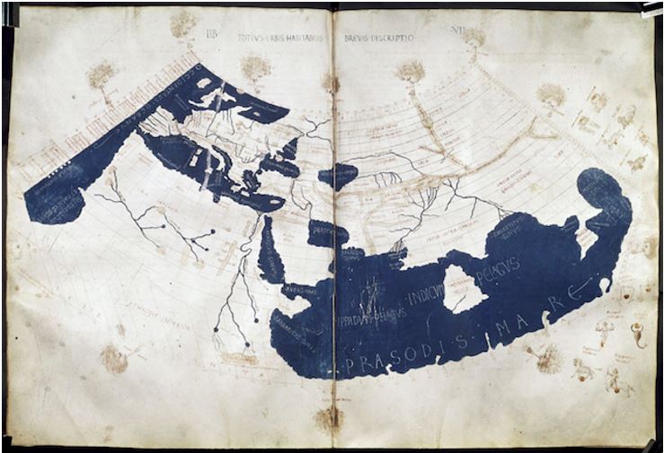
Public domain. Credited to Francesco di Antonio del Chierico. Available at http://upload.wikimedia.org/wikipedia/commons/2/23/PtolemyWorldMap.jpg.
- Source A: Map bank: 1st and 2nd Century CE global trade route maps
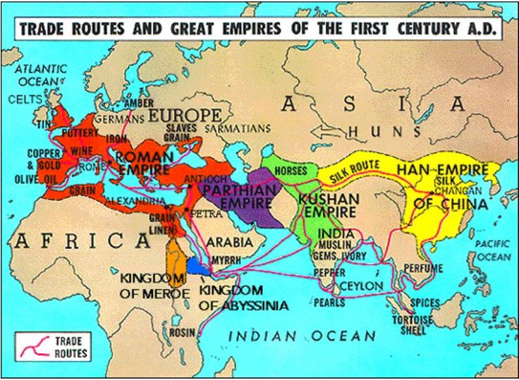
- Map 1: Map illustrating various global trade route maps, “Trade Routes and Great Empires of the First Century A.D.” 2010.
Reproduced with permission from Dr. Neil Goldberg, The Dalton School. http://people.uncw.edu/zervosg/Pr236/New%20236/Public%20Domain%20for%20Web/EmpiresICE.JPG - .
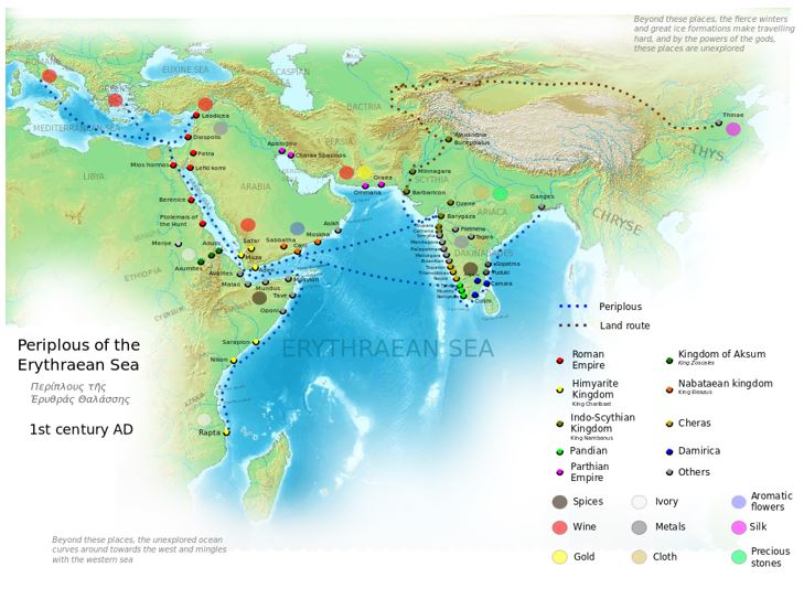
- Map 2: Map illustrating land and sea trade routes between Europe and Asia, “Periplous of the Erythraean Sea, 1st century AD,” 2014.
© George Tsiagalakis. Reproduced under the Creative Commons Attribution-Share Alike 4.0 License. https://commons.wikimedia.org/wiki/File:Periplous_of_the_Erythraean_Sea.svg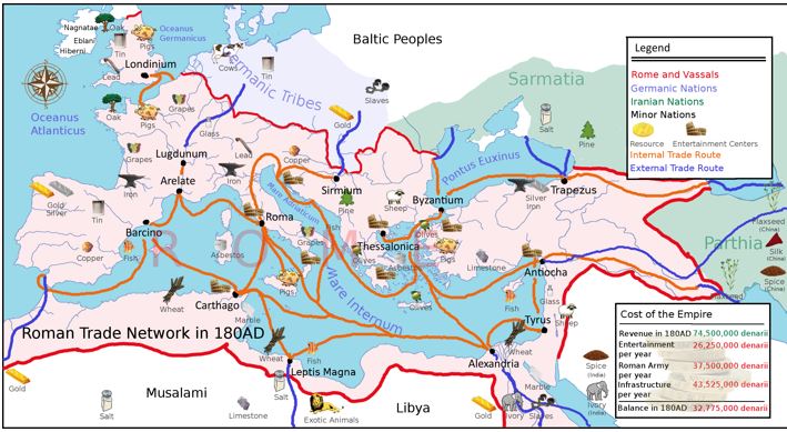
- Map 3: Map illustrating trade routes in the Roman Empire, “Roman Trade Network in 180 AD,” 2010.
© Adhavoc. Reproduced under the Creative Commons Attribution-Share Alike 3.0 Unported License. https://commons.wikimedia.org/wiki/File:Europe_180ad_roman_trade_map.png